Morris Area Paratransit System (MAPS)
地区
- America
国家
- United States
产品
- Ecolane Reporting System
- Ecolane DRT
- Ecolane Touch Screen MDT
技术栈
- Android Tablets
- Turn-by-turn Navigation
实施规模
- Enterprise-wide Deployment
影响指标
- Productivity Improvements
- Customer Satisfaction
技术
- 功能应用 - 车队管理系统 (FMS)
- 功能应用 - 远程监控系统
适用行业
- 运输
适用功能
- 物流运输
- 商业运营
用例
- 车队管理
- 预测性维护
- 远程资产管理
服务
- 系统集成
- 软件设计与工程服务
关于客户
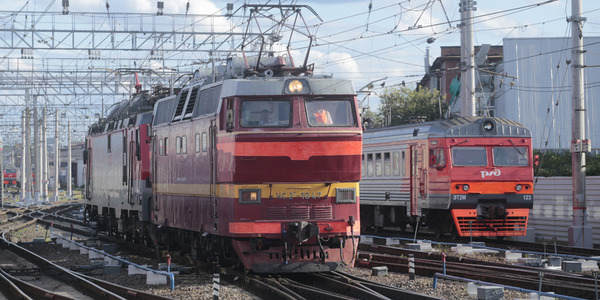
The Morris Area Paratransit System (MAPS) is a transportation service provider operating in Morris County, United States. The service is designed to cater to the unique needs of the county, which includes both urban and rural areas. MAPS aims to provide efficient and reliable transportation services to its users, which include a diverse range of passengers such as the elderly, disabled, and those without access to private transportation. The organization is committed to improving its operational efficiency and customer satisfaction by leveraging modern technology solutions.

挑战
The Morris Area Paratransit System (MAPS) faced several operational challenges. They were still using paper manifests, which made it difficult to operate efficiently and streamline internal operations. The unique geography of Morris County, which includes both urban and rural areas, required a system that could map out different areas effectively. Additionally, they needed to break out different funding sources and required software that was easy to use. Another critical need was the integration of tablets in their vehicles to modernize their operations.
解决方案
To address these challenges, MAPS implemented the Ecolane Reporting System along with an ADHOC reporting tool. The Ecolane DRT software was used to completely automate scheduling and dispatching, significantly improving operational efficiency. Additionally, the Ecolane Touch Screen MDT software, which includes turn-by-turn navigation, was deployed on Android tablets in their vehicles. This solution allowed MAPS to do more miles and report rural miles more accurately, thereby meeting their unique geographic needs. The integration of these technologies streamlined their operations and provided a more user-friendly experience for their staff.
运营影响
数量效益

Case Study missing?
Start adding your own!
Register with your work email and create a new case study profile for your business.
相关案例.

Case Study
Airport SCADA Systems Improve Service Levels
Modern airports are one of the busiest environments on Earth and rely on process automation equipment to ensure service operators achieve their KPIs. Increasingly airport SCADA systems are being used to control all aspects of the operation and associated facilities. This is because unplanned system downtime can cost dearly, both in terms of reduced revenues and the associated loss of customer satisfaction due to inevitable travel inconvenience and disruption.

Case Study
IoT-based Fleet Intelligence Innovation
Speed to market is precious for DRVR, a rapidly growing start-up company. With a business model dependent on reliable mobile data, managers were spending their lives trying to negotiate data roaming deals with mobile network operators in different countries. And, even then, service quality was a constant concern.
Case Study
Digitize Railway with Deutsche Bahn
To reduce maintenance costs and delay-causing failures for Deutsche Bahn. They need manual measurements by a position measurement system based on custom-made MEMS sensor clusters, which allow autonomous and continuous monitoring with wireless data transmission and long battery. They were looking for data pre-processing solution in the sensor and machine learning algorithms in the cloud so as to detect critical wear.
Case Study
Cold Chain Transportation and Refrigerated Fleet Management System
1) Create a digital connected transportation solution to retrofit cold chain trailers with real-time tracking and controls. 2) Prevent multi-million dollar losses due to theft or spoilage. 3) Deliver a digital chain-of-custody solution for door to door load monitoring and security. 4) Provide a trusted multi-fleet solution in a single application with granular data and access controls.

Case Study
Vehicle Fleet Analytics
Organizations frequently implement a maintenance strategy for their fleets of vehicles using a combination of time and usage based maintenance schedules. While effective as a whole, time and usage based schedules do not take into account driving patterns, environmental factors, and sensors currently deployed within the vehicle measuring crank voltage, ignition voltage, and acceleration, all of which have a significant influence on the overall health of the vehicle.In a typical fleet, a large percentage of road calls are related to electrical failure, with battery failure being a common cause. Battery failures result in unmet service agreement levels and costly re-adjustment of scheduled to provide replacement vehicles. To reduce the impact of unplanned maintenance, the transportation logistics company was interested in a trial of C3 Vehicle Fleet Analytics.

Case Study
3M Gains Real-Time Insight with Cloud Solution
The company has a long track record of innovative technology solutions. For example, 3M helps its customers optimize parking operations by automating fee collection and other processes. To improve support for this rapidly expanding segment, 3M needed to automate its own data collection and reporting. The company had recently purchased the assets of parking, tolling, and automatic license plate reader businesses, and required better insight into these acquisitions. Chad Reed, Global Business Manager for 3M Parking Systems, says, “With thousands of installations across the world, we couldn’t keep track of our software and hardware deployments, which made it difficult to understand our market penetration.” 3M wanted a tracking application that sales staff could use to get real-time information about the type and location of 3M products in parking lots and garages. So that it could be used on-site with potential customers, the solution would have to provide access to data anytime, anywhere, and from an array of mobile devices. Jason Fox, Mobile Application Architect at 3M, upped the ante by volunteering to deliver the new app in one weekend. For Fox and his team, these requirements meant turning to the cloud instead of an on-premises datacenter. “My first thought was to go directly to the cloud because we needed to provide access not only to our salespeople, but to resellers who didn’t have access to our internal network,” says Fox. “The cloud just seemed like a logical choice.”
