Geologic Mapping

公司规模
1-10
地区
- America
国家
- United States
产品
- Fulcrum
技术栈
- GPS-enabled devices
- Mapbox Satellite
实施规模
- Pilot projects
影响指标
- Digital Expertise
- Productivity Improvements
技术
- 应用基础设施与中间件 - 数据交换与集成
适用行业
- 教育
适用功能
- 产品研发
用例
- 地理围栏
- 远程资产管理
服务
- 云规划/设计/实施服务
关于客户
Green Mountain College is an educational institution that uses geologic mapping to study, explore, and evaluate many environmental issues in Vermont. The college focuses on a variety of issues from characterizing groundwater resources, to evaluating landslide susceptibility, to characterizing the impacts of storm events like Tropical Storm Irene. The college has been trying to streamline their traditional mapping techniques over the last decade by moving from an inexpensive consumer grade Garmin, to the Trimble GeoXT and the Trimble Juno, to Collector for ArcGIS running on an iPad mini.

挑战
Green Mountain College was facing challenges in streamlining their traditional mapping techniques which involved the use of paper maps, a field notebook, camera, and handheld GPS. Over the years, they tried different technologies including an inexpensive consumer grade Garmin, the Trimble GeoXT and the Trimble Juno, to Collector for ArcGIS running on an iPad mini. However, many of these options still required paper maps, external camera or additional software to create data dictionaries. The college was in need of a solution that could combine all the needs of traditional mapping within a single interface.
解决方案
The college tested Fulcrum while mapping the surficial geology of Monkton, Vermont and found that it combines all the needs of traditional mapping within a single interface. The browser-based Fulcrum interface allows for easy creation and management of a database with required fields and visibility rules that can control input and maintain data consistency across multiple users. This means that state surveys, consulting firms, and students working on group projects can save time at the end of a project by not having to merge data with different field names, formation abbreviations, etc. In addition to keeping data structure consistent, users are able to add their own layers and download them for offline use. This is one of the most useful tools in Fulcrum for geologic mapping because you can include any map you would normally carry in paper format and visualize field relationships across multiple overlays.
运营影响

Case Study missing?
Start adding your own!
Register with your work email and create a new case study profile for your business.
相关案例.

Case Study
IoT platform Enables Safety Solutions for U.S. School Districts
Designed to alert drivers when schoolchildren are present, especially in low-visibility conditions, school-zone flasher signals are typically updated manually at each school. The switching is based on the school calendar and manually changed when an unexpected early dismissal occurs, as in the case of a weather-event altering the normal schedule. The process to reprogram the flashers requires a significant effort by school district personnel to implement due to the large number of warning flashers installed across an entire school district.
Case Study
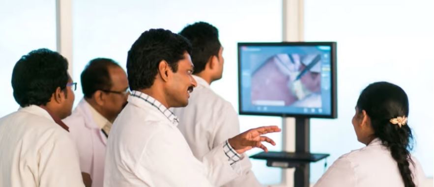
Revolutionizing Medical Training in India: GSL Smart Lab and the LAP Mentor
The GSL SMART Lab, a collective effort of the GSL College of Medicine and the GSL College of Nursing and Health Science, was facing a challenge in providing superior training to healthcare professionals. As clinical medicine was becoming more focused on patient safety and quality of care, the need for medical simulation to bridge the educational gap between the classroom and the clinical environment was becoming increasingly apparent. Dr. Sandeep Ganni, the director of the GSL SMART Lab, envisioned a world-class surgical and medical training center where physicians and healthcare professionals could learn skills through simulation training. He was looking for different simulators for different specialties to provide both basic and advanced simulation training. For laparoscopic surgery, he was interested in a high fidelity simulator that could provide basic surgical and suturing skills training for international accreditation as well as specific hands-on training in complex laparoscopic procedures for practicing physicians in India.
Case Study
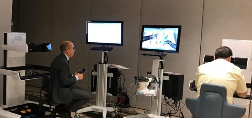
Implementing Robotic Surgery Training Simulator for Enhanced Surgical Proficiency
Fundacio Puigvert, a leading European medical center specializing in Urology, Nephrology, and Andrology, faced a significant challenge in training its surgical residents. The institution recognized the need for a more standardized and comprehensive training curriculum, particularly in the area of robotic surgery. The challenge was underscored by two independent studies showing that less than 5% of residents in Italian and German residency programs could perform major or complex procedures by the end of their residency. The institution sought to establish a virtual reality simulation lab that would include endourological, laparoscopic, and robotic platforms. However, they needed a simulator that could replicate both the hardware and software of the robotic Da Vinci console used in the operating room, without being connected to the actual physical console. They also required a system that could provide both basic and advanced simulation training, and a metrics system to assess the proficiency of the trainees before they performed surgical procedures in the operating theater.

Case Study
Edinburgh Napier University streamlines long-distance learning with Cisco WebEX
• Geographically dispersed campus made in-person meetings costly and inconvenient.• Distance-learning programs in Malaysia, India, and China required dependable, user-friendly online tools to maximize interaction in collaborative workspaces.• Virtual learning environment required a separate sign-in process, resulting in a significant administrative burden for IT staff and limited adoption of collaboration technology.

Case Study
8x increased productivity with VKS
Before VKS, a teacher would spend a lot of time showing a group of 22 students how to build a set of stairs within a semester of 120 hours. Along with not leaving the teacher much time to provide one-on-one support for each student to properly learn carpentry, it also left a considerable amount of room for error. Key information would be misinterpreted or lost as the class was taught in the typical show-and-tell way.

Case Study
Scalable IoT Empowering GreenFlex's Sustainable Growth
GreenFlex, a company that supports sustainable development, decarbonization, and energy efficiency, faced several challenges in its quest to expand its business. The company needed to deploy a robust and sustainable IoT technology to support its growth. It was crucial for them to monitor and control devices at customer sites in a safe and reliable manner. They also needed to integrate devices across a range of communication protocols and gather and act on data to meet efficiency targets. GreenFlex had previously built IoT capabilities into its digital platform, GreenFlexIQ, to monitor and manage customer sites remotely. However, they soon realized that they needed a new platform to support their ambitions. They needed a platform that could scale to connect more devices for production management and make it easier for the operations team to manage devices in the field.
