Innovative utility inspections using Fulcrum, GIS and 3D imaging

Customer Company Size
Mid-size Company
Region
- America
Country
- United States
Product
- Fulcrum’s Field Inspection Management platform
- Esri ArcGIS Online geospatial information system (GIS)
- 3D imaging software
Tech Stack
- GIS
- 3D Imaging
- Mobile Inspection Apps
Implementation Scale
- Enterprise-wide Deployment
Impact Metrics
- Productivity Improvements
- Digital Expertise
Technology Category
- Application Infrastructure & Middleware - Data Exchange & Integration
Applicable Industries
- Utilities
- Cities & Municipalities
Applicable Functions
- Maintenance
- Quality Assurance
Use Cases
- Asset Health Management (AHM)
- Infrastructure Inspection
- Real-Time Location System (RTLS)
Services
- Software Design & Engineering Services
- System Integration
About The Customer
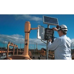
TREKK Design Group, LLC (TREKK) is a Missouri-based civil engineering firm founded in 2002. The company's mission is to engineer holistic, commonsense solutions that support the growth and restoration of the communities it serves. TREKK provides a wide range of expertise to municipalities, specifically for utilities and transportation, encompassing design and planning, geospatial information systems and asset management, and construction engineering and inspections. They describe their services portfolio as follows: “Need a road designed? We can help. Want to understand your underground infrastructure? We can do that, too. Have a problem and just need a commonsense solution? We’ve got you covered.”

The Challenge
TREKK Design Group, a civil engineering firm, was facing several challenges with their inspection and data collection processes. They were using outdated paper-based inspections which were not compatible with their existing Access databases and EsriTM ArcGIS OnlineTM. They were also facing quality control issues with their field data collection, including inaccurate or irrelevant data and missing location information. Inspections of incorrect assets or structures within complex lines or grids were also a problem due to inaccessible or missing spatial components. The teams were also frustrated with non-purpose built inspection and data collection tools while trying to deliver on customer reporting and compliance requirements. Unreliable hotspots and Internet connection also resulted in teams “flying blind” in the field, unable to access databases or reliably collect information.
The Solution
TREKK leveraged a powerful technology portfolio which includes Fulcrum’s Field Inspection Management platform, the Esri ArcGIS Online geospatial information system (GIS), and 3D imaging software to deliver to its clients a 360° view of their field assets and utility operations. They used Fulcrum to develop 'smart' client and project-specific mobile inspection apps that enable data integration and use across GIS, asset management, and other client operations platforms. Fulcrum's features such as automatic geotagging of all inspection records and data points using mobile device location intelligence, as well as mandatory, unskippable fields and conditional logic, ensured thoroughness and accuracy of inspections and field assessments. The platform also allowed teams to use databases and collect geotagged information for later syncing, without worrying about a network.
Operational Impact
Quantitative Benefit

Case Study missing?
Start adding your own!
Register with your work email and create a new case study profile for your business.
Related Case Studies.

Case Study
Turning A Stadium Into A Smart Building
Honeywell created what it called the “intelligent system” for the National Stadium in Beijing, China, turning the venue for the opening and closing events at the 2008 Summer Olympics into a “smart building.” Designed by highly controversial artist Ai Weiwei, the “Bird’s Nest” remains one of the most impressive feats of stadium architecture in the world. The 250,000 square meter structure housed more than 100,000 athletes and spectators at a time. To accommodate such capacity, China turned to Honeywell’s EBI Integrated Building Management System to create an integrated “intelligent system” for improved building security, safety and energy efficiency.

Case Study
IoT Solutions for Smart City | Internet of Things Case Study
There were several challenges faced: It is challenging to build an appliance that can withstand a wide range of voltage fluctuations from as low at 90v to as high as 320v. Since the device would be installed in remote locations, its resilience was of paramount importance. The device would have to deal with poor network coverage and have the ability to store and re-transmit data if networks were not available, which is often the case in rural India. The device could store up to 30 days of data.

Case Study
Automation of the Oguz-Gabala-Baku water pipeline, Azerbaijan
The Oguz-Gabala-Baku water pipeline project dates back to plans from the 1970’s. Baku’s growth was historically driven by the booming oil industry and required the import of drinking water from outside of the city. Before the construction of the pipeline, some 60 percent of the city’s households received water for only a few hours daily. After completion of the project, 75 percent of the two million Baku residents are now served around the clock with potable water, based on World Health Organization (WHO) standards. The 262-kilometer pipeline requires no pumping station, but uses the altitude differences between the Caucasian mountains and the capital to supply 432,000 m³/d to the Ceyranbatan water reservoir. To the people of Baku, the pipeline is “the most important project not only in 2010, but of the last 20 years.”
Case Study
GPRS Mobile Network for Smart Metering
Around the world, the electricity supply industry is turning to ‘smart’ meters to lower costs, reduce emissions and improve the management of customer supplies. Smart meters collect detailed consumption information and using this feedback consumers can better understand their energy usage which in turn enables them to modify their consumption to save money and help to cut carbon emissions. A smart meter can be defined in many ways, but generally includes an element of two-way communication between the household meter and the utility provider to efficiently collect detailed energy usage data. Some implementations include consumer feedback beyond the energy bill to include online web data, SMS text messages or an information display in consumers’ premises. Providing a cost-effective, reliable communications mechanism is one of the most challenging aspects of a smart meter implementation. In New Zealand, the utilities have embraced smart metering and designed cost effective ways for it to be implemented. The New Zealand government has encouraged such a move to smart metering by ensuring the energy legislation is consistent with the delivery of benefits to the consumer while allowing innovation in this area. On the ground, AMS is a leader in the deployment of smart metering and associated services. Several of New Zealand’s energy retailers were looking for smart metering services for their residential and small business customers which will eventually account for over 500,000 meters when the multi-year national deployment program is concluded. To respond to these requirements, AMS needed to put together a solution that included data communications between each meter and the central data collection point and the solution proposed by Vodafone satisfied that requirement.
.png)
Case Study
Smart Street Light Network (Copenhagen)
Key stakeholders are taking a comprehensive approach to rethinking smart city innovation. City leaders have collaborated through partnerships involving government, research institutions and solution providers. The Copenhagen Solutions Lab is one of the leading organizations at the forefront of this movement. By bringing together manufacturers with municipal buyers, the Copenhagen Solutions Lab has catalyzed the development and deployment of next-generation smart city innovations. Copenhagen is leveraging this unique approach to accelerate the implementation of smart city solutions. One of the primary focus areas is LED street lighting.

Case Study
NB-IoT connected smart meters to improve gas metering in Shenzhen
Shenzhen Gas has a large fleet of existing gas meters, which are installed in a variety of hard to reach locations, such as indoors and underground, meaning that existing communications networks have struggled to maintain connectivity with all meters. The meter success rate is low, data transmissions are so far unstable and power consumption is too high. Against this background, Shenzhen Gas, China Telecom, Huawei, and Goldcard have jointly trialed NB-IoT gas meters to try and solve some of the challenges that the industry faces with today’s smart gas meters.
